

Photo by Mark Dobbs
A steep hike to Heart Lake in Ladysmith B.C.
- When – All times of year.
- Where – Mid-island (Ladysmith).
- Why – Hike to view point.
- How – Hiking.
- Difficulty – Hard (steep)
- Cost – Walking is free
Directions / Location
- 48.9874519, -123.8315080 – Parking / Trail head.
- 48.9701041, -123.8313511 – Heart Lake.
- From Hwy 1 turn onto 1st avenue, continue for 170 meter.
- Turn right at the roundabout onto Symonds street, continue for 1.3 km (Symonds st turns into Dunsmuir crescent).
- Turn left onto Malone road, continue for 100 meters.
- Turn right onto Mackie road, continue for 250 meters.
- Turn right at the Heart Lake trail parking lot and trail head.
- – Google map directions: https://goo.gl/maps/JVnTV4MfTHuX5mQZ6
The Hike
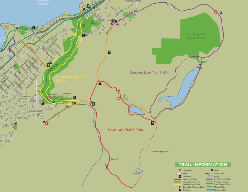
The well marked hike up to heart lake involves a variety of different trail conditions, but the views from the straight up grind are worth every switchback.
The trail head starts from the parking lot and runs along part of the Holland Creek trail. Follow the wide, well groomed foot path until you reach a logging road with a marker pointing south. A few hundred meters down the logging you’ll find a Y in the in the road with a trail map. At this point you can decide which direction to take – the longer route to the West (turn right) or the steeper and more direct route to the East (turn left). Both routes will lead you to Heart Lake and are part of the Heart Lake Loop. This time I went East (to the left).

Photo by Mark Dobbs.
After hiking about 450 meters East down the logging road, you will find a set of concrete stairs with another trail map beside them. This marks the change in terrain where the trail turns from a stroll along a gravel road to a single track grind. The grade is gradual at first, but quickly becomes steeper. You can follow the switchbacks to make it a bit easier or you can choose the path straight up through the trees. The ground in this area is loose and requires careful footing to prevent slips, especially on the way back down. About 2/3 of the way up there’s a rocky outcropping with an opening in the trees offering views of southern Ladysmith, the ocean, and Thetis Island. Continue heading up the trail after taking in the views, you’ll know you’re almost there when the terrain becomes a bit easier and the ground starts to level out. Once you reach the top (and the lake), there is plenty of room on the rock ledge to take a rest, hang out, and take in the view. There is an optional trail that circles the lake, if you feel like exploring a little further. When you’re ready to head out, you can either turn around and head back down the way you came (watch your footing), or you can continue with the main Heart Lake trail loop. On this occasion, I chose to head back down after completing the trail around the lake

